Texas State Guard receives training from SFA on GPS applications
By TYESHA BOUDREAUX
2008/08/21
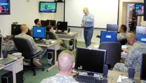 Charles Ashton, SFA geospatial trainer I, briefs Texas State Guard members on what they will be learning during a GPS training. The purpose of the training is to familiarize guard members with introductory GPS applications. The training will continue through Sunday.Photo by Tyesha Boudreaux/The Daily Sentinel
The Columbia Regional Geospatial Center at SFA is hosting two GPS applications trainings for the Texas State Guard.
The first training began Wednesday and will last until Sunday. The second training will begin Wednesday, Aug. 27, and will end Sunday, Aug. 31.
The purpose of the training is to familiarize 24 guard members with introductory GPS applications, according to Charles Ashton, SFA geospatial trainer I and graduate student.
Under the direction of Texas Gov. Rick Perry, the Texas State Guard is a voluntary force that is an emergency response asset to the state, Ashton said.
"We’re working with the Texas State Guard to have a unified and coordinated effort using GPS/GIS technologies during an emergency-response event," Ashton said. "And this is going to allow the guard to already have a familiarity and a working relationship with us so that in a time of an emergency we’re not all just discovering each other. We’ve already worked together, trained together and we have a process in place to help do area-damage assessment after an emergency event."
Areas that the training will cover include the usage of topographic maps and geospatial tools in emergency management.
On Friday, guard members will complete a field reconnaissance exercise in downtown Nacogdoches to see what kind of assets it has for an emergency response, Ashton said. An emergency operation center will also be put in place.
"That’s one of the first things you do," he said. "You get the EOC up, and you start coordination efforts of all the people involved."
On Saturday, the guard will complete a wide-area damage assessment at SFA that will simulate hurricane damage on campus, he said.
On the last day of each session, guard members will participate in a rescue, recovery and damage assessment field exercise on SFA property located at the corner of University Drive and Starr Avenue.
The Columbia Center completed the first GPS training, which was a trial run, with the Texas State Guard in December 2007, Ashton said. Since then, 150 guard members have been trained on GPS introduction applications. "Our commitment is to help the guard respond as much as possible to any emergency-response event," he said.