 |
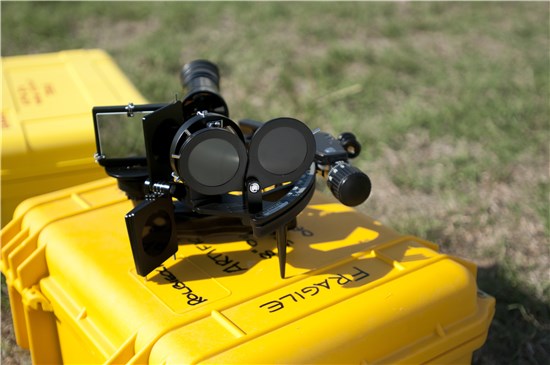
| A sextant, the same tool used by the Lewis and Clark Expedition in the early 1800s to map the western United States, and is still being used today by the Texas Military Forces (TXMF). David Rolbiecki, Chief of survey for the TXMF, uses this sextant to obtain precise measurements of the earth. Rolbiecki is hoping to use his research to feed the National Geodetic Survey, and ultimately help to improve elevation measurements for the Global Positioning System, or GPS. (U.S. Army National Guard photo by Capt. Martha C. Nigrelle/Released) |
Story by: Capt. Martha Nigrelle
CAMP MABRY, Texas - In 1804, President Thomas Jefferson enlisted Meriwether Lewis and William Clark to lead an expedition across the western frontier to the Pacific Ocean, to “record the face of the country.” As history books can attest, the Corps of Discovery Expedition was a success. Today, some of the same methods Lewis and Clark used in the 1800s to map the new territory, and the future of the United States, are being utilized in the Texas Military Forces (TXMF).
David Rolbiecki, Registered Professional Land Surveyor of the State of Texas and Chief of Survey for the TXMF oversees land surveying for the organization and introduced the classic practice of geodetic astronomy, using the sun, moon and stars to conduct measurements of the earth, at Camp Mabry, in Austin, Texas.
According to records at the Library of Congress, Lewis and Clark created the first maps of the mid west and western portions of the United States. They started at Lake Michigan and extended out to the Pacific Ocean. In order to properly chart these maps, Lewis, using geodetic astronomy, took astronomic observations (looking at the stars) along key points, thus enabling him to ascertain latitude and longitude and create a more accurate map.
With online maps, Global Positioning Systems (GPS), and google earth, one might think this practice is no longer necessary.
Rolbiecki explained that the National Geodetic Survey (NGS), an agency that falls under National Oceanic and Atmospheric Administration, and works with the Department of Defense’s Global Positioning System (GPS), to provide the framework for all GPS positioning activities in the U.S. is extremely accurate when measuring horizontal distances, but when looking at GPS derived elevation data, GPS is not quite as accurate. NGS is looking to improve this, using astronomic observations to augment GPS observations used in gravity research.
Shooting from what looks like a concrete post situated in the middle of a field at Camp Mabry, Rolbiecki and Mark Hinojosa, a TXMF Land Survey Technician, are using replicas of the same equipment used by Lewis and Clark. Using their equipment and methods, Rolbiecki is able to look to the stars for accurate latitude and longitude readings.
And the concrete post - a permanent astro-geodetic pier which is an extremely accurate and stable platform to use for astro-geodetic observations.
“The purpose of the pier is to add a permanent, high-accuracy legacy monument to the existing Camp Mabry survey control network,” said Rolbiecki. The astro-geodetic pier provides a platform for precise astronomic observations using optical theodolites, and training in celestial observations using a marine sextant - all tools of the geodetic practice.
“Establishing the astro-pier at Camp Mabry benefits any planning and design endeavors [for the TXMF]. It also allows an opportunity to learn how to perform astrometric observations and practice celestial navigation,” said Kristin Mt Joy, Cultural Resource Program manager for TXMF and a registered professional archeologist.
Rolbiecki first joined the Army in 1982 as a geodetic surveyor and spent time surveying for the Army in Virginia, Hawaii, and Maine before coming back to Texas. He is currently on the board of editors for the Journal of Surveying Engineering and is also a chief warrant officer for the Texas Army National Guard. For his guard duties, he is a planner, but when he comes to work at Camp Mabry, Rolbiecki is known as the man who is passionate about astro-geodetic work.
“Mr. Rolbiecki is very smart and sometimes it is hard to translate his knowledge and skill set! But cultural resources has learned a lot since partnering with his team,” said Mt Joy.
Rolbiecki’s unique skill set has benefited both the land survey department, as well as, the cultural resources department of the TXMF.
“The Cultural Resources Program has been partnering with the land survey team to record historic features across Camp Mabry's historic district. The astro-pier established by Mr. Rolbiecki not only provides a permanent station for geospatial reference, it has allowed the cultural resources staff to learn about how mapping and orientations were derived with historic equipment,” said Maj. Richard Martinez, environmental manager for the TXMF. “At an upcoming archaeological conference in 2014, military archaeologists and academics will have an opportunity to see demonstrations of orienting at the astro-pier.“
“[Astronomic] observations on land are obsolete due to high-accuracy GPS,” explained Rolbiecki. “I still practice this science and art.”
According to the NGS official website, the vertical data they are looking for would provide elevation accuracy within a two centimeters level from almost any location in the U.S., improving location information to the millions of people who use GPS every day. In order to complete this project it is necessary to measure the stars. NGS is actively recruiting people who can conduct these celestial surveys.
Rolbiecki is hoping to be one of those people.
In the mean time, Rolbiecki set up the astro-geodetic pier, or control station, on Camp Mabry in order to have a precise location from which to measure the sun, the stars, and the moon. This paired with his sextant, artificial horizon and chronometer, the same tools that Lewis used 200 years ago, has set Rolbiecki up to record the face of Texas for the future.